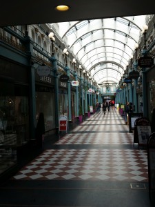
SIGHT (Great Western Arcade): Continue along Temple Row for a few extra feet, and go through the Great Western Arcade on your left. Despite its name, this is actually a rather small arcade, named for the Great Western Railway who built it in 1876/77 to span a tunnel between Moor Street and Snow Hill stations. Part of the arcade, including the entrance at Colmore Row and the original roof, suffered bomb damage during World War II and were rebuilt in a different style than the original.
The arcade is home to a number of interesting shops including Hollingsworth Cigars (second oldest tobacconist in the UK) and Mr Simms Olde Sweet Shoppe (which fits in beautifully with the overall style of the arcade, but which is actually part of a major chain of stores).
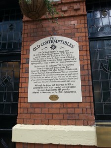
PINT (The Old Contemptibles): Leaving the Great Western Arcade, you are now just across the road from Snow Hill Rail station. Walk down Livery St. on the left side of the station, and on the second corner on your left you will find The Old Contemptibles. This is an atmospheric and traditional Nicholson’s pub, whose name honours the British Expeditionary Force, which suffered heavy casualties in holding up the German advance at Mons during World War 1. It is located in the business district, and as such gets rather busy during lunch hours, but it is worth it. Food is decent and the place has a fine selection of real ales. If you haven’t already had a bite, have it here – or just have a pint, before traversing the Queensway to enter the Jewellery Quarter.
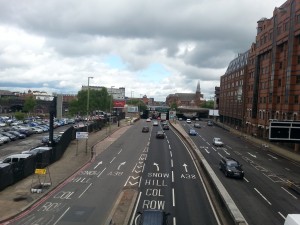
SIGHT (Queensway): From The Old Contemptibles walk down Edmund St and turn right at your first opportunity. Continue down Church Street, passing The Old Royal on the way, until you reach the massive Queensway. The Queensway was built between 1957 and 1971 as an Inner Ring Road, designated A4400, completely encircling the Birmingham city center. Originally only a small part of the road was intended to be named Queensway, but when the actual queen, Elizabeth II, inadvertently referred to the entire ring road as Queensway when she attended the formal opening in April 1971, the name stuck. Known as a “Concrete collar”, making expansion and redevelopment of the city difficult, some parts of the Inner Ring Road were eventually changed to better accomodate pedestrian traffic, and only parts of the original Inner Ring Road remains unchanged today. The part which you are now going to cross is one such original stretch, although it has today been incorporated into the A38, the longest 2-digit A road in England connecting Bodmin in Cornwall with Mansfield in Nottinghamshire.
Ascend the footbridge from the building on the corner of Church St. and Queensway and “enjoy” the view from the top.
SIGHT (BT Tower): From the foot bridge you have an excellent view of the BT Tower, built between 1963 and 1965 and still the tallest structure in Birmingham at 152 metres. There is no public access inside the tower itself, which is for the most part an empty shell. Unlike the BT Tower in London, this one has never had a restaurant or a viewing platform, as it was considered unlikely that anyone would want to see the skyline of Birmingham.


